Wednesday, June 2, 2010
Drummond Island
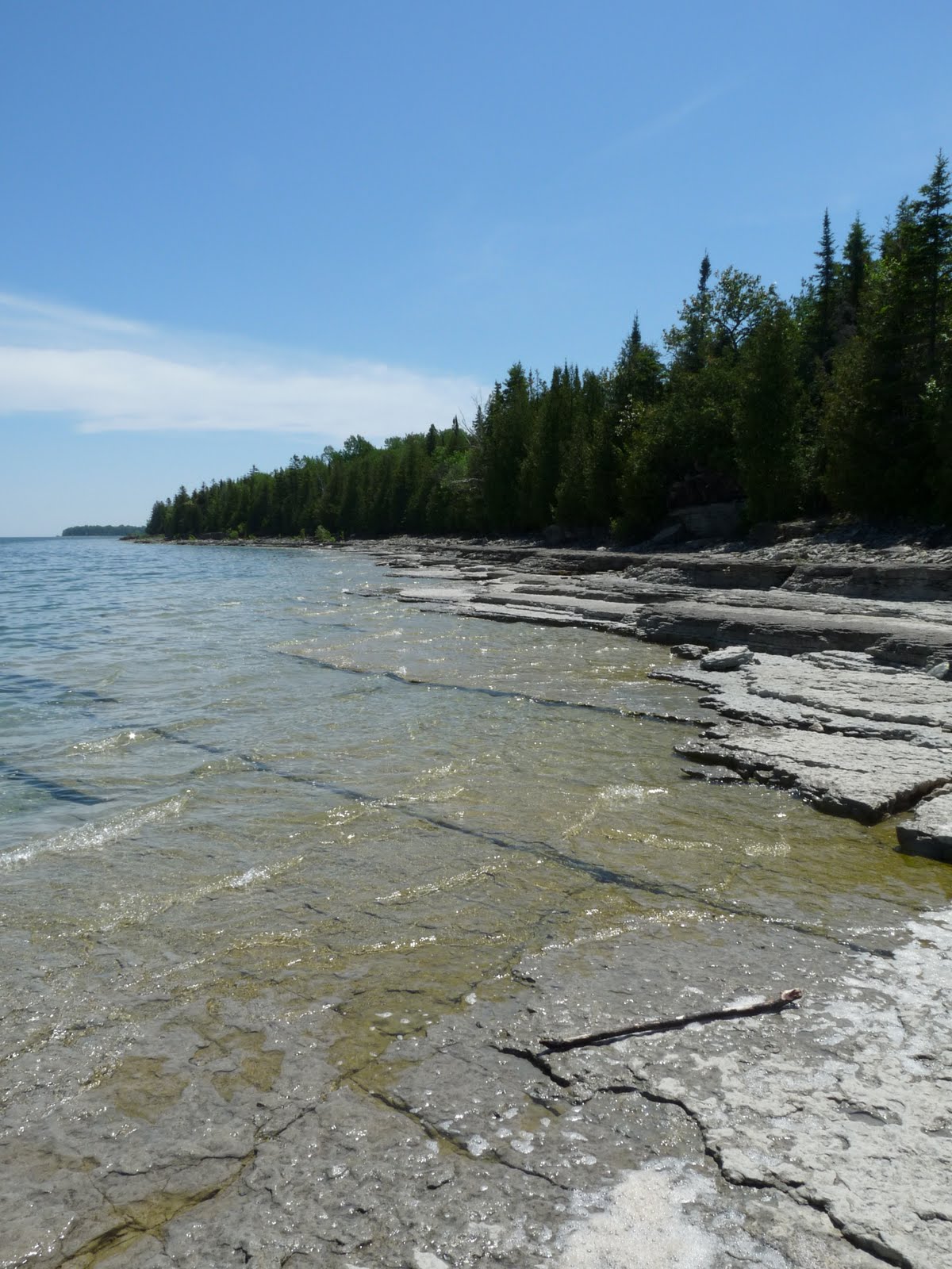
The "must-see" sights were the historical museum, the Maxton Plains, and the fossil ledges. The museum was actually closed so that left the other two sights. A short drive led me to the Maxton Plains and they really weren't that exciting to me. I walked through them a little bit and didn't see anything that would make them a must see sight for me. From the Maxton Plains, the fossil ledges were only about 5 miles away. However, the road was loose with tons of large rocks. It was a terrible road for driving, biking, or walking, but driving seemed to be the best choice. After the treacherous drive, I don't think the fossil ledges were worth it. While it was a beautiful and unique scene, there wasn't anything particularly striking about it. Once at this beach, you could along it shores in both directions for a total of up to a mile according to the website.
Aside from the "must-see" sights, the website also mentioned that a hike could be from the Glen Cove Beach to the Marble Head Viewpoint. To be continued...
Thursday, January 14, 2010
Lack of updates
I apologize that I haven't really done anything with the blog in a couple months. Exam time came around and then I was busy with work. Now I have what looks like is going to be a busy semester, but I will try to get some more posts done. I hope that in the meantime everyone will at least find the links useful as you will be able to find almost every trail or place open for hiking in the UP amongst those.
Tuesday, November 3, 2009
Anne and Cameron Waterman Preserve at Mt. Benison
 The Anne and Cameron Waterman Preserve at Mt. Benison
is a special hiking destination surrounded completely by the Huron Mountain Club. The preserve is operated by The Nature Conservancy and while it is open to the public, it is limited to guided access only due to its location.
I happened to be looking up peaks in Marquette County to see if anything came up and I came across this preserve. It is stated that access to the preserve is by staff-led field trips and volunteer days only. I contacted about visiting, but I didn't get my hopes up because I wasn't sure what the chances were of visiting. After waiting over a month for a reply, I happened to check my spam folder to see that someone had replied within a week. It had said that it would be possible but they wanted some more information. Eventually we had set a date for staff-led field trip and I became very excited to visit.
This ended up being one of the best hikes that I have ever done. We drove out to Big Bay from Marquette and took the Huron Mountain Club Rd to the gate. The man verified who was with us, opened the gate and gave us a key for another gate. The drive through the HMC was very long, but very exciting being able to see an area that many never have. The day was very dark and cloudy, so we couldn't see very far that morning. However, hints of lakes could seen. Compared to the typical UP woods, the woods here were all old growth forest with huge trees and a lack of undergrowth.
While the scenery was nice, it took over 40 minutes for us to drive across to the preserve going only 10 mph on undeveloped roads before finally reaching the second gate. Beyond the second gate, we only traveled a little ways until the truck could go no further. Then, we walked the road to the preserve. There were many trails leading off to different hills and lakes that we past. It was so tempting to head off on these (especially on the way back), but it was strictly prohibited. The Nature Conservancy is granted to access to reach their preserve, but that is it, the other land is still off limits. Finally reaching the preserve, we traversed rugged, pristine land by the guide of a GPS and maps. This was really my first off trail hike and I must say that I greatly enjoyed it. Although, I think I would need some training to be able to do it without the help of a guide.
The preserve is quite large, so we only hiked a small portion of it in the northeast corner. We ended up making a loop, first heading to the Mink Run Creek and then up on a ridge for some views. The Mink Run Creek was crystal clear and had little drops creating pristine and mystifying scenes unlike anything I had ever seen. The views were quite limited. There really was only one or two places that you could even see beyond the trees and with the weather being so foggy you couldn't see very far. However, it did make a neat effect for the photos with all the layers of the Hurons. We were looking to the South and could see what I believe was Mountain Lake.
Anyone interested in visiting should contact The Nature Conservancy. It sounded like they've made a visit to the preserve each fall since they acquired the land, but I have no idea of how often they plan on returning. This provides a wonderful opportunity for anyone who is wanting to see the HMC. Another option to see the HMC is through the Marquette County History Museum's fundraiser at Ives Lake. In the past it has included a meal, some history and a hike up the Breakfast Roll. They plan on doing it again in Spring/Summer 2010.


Friday, October 30, 2009
Pine Marten Run
 The Pine Marten Run is a 26 mile trail system about 30 miles NW of Manistique or 17 miles S of Munising. It consists of 5 loops connected through spurs. The trails wrap around 13 different lakes and follow the Indian River in a couple short sections. During the spring, summer, and fall it is used for hiking and horseback riding. I haven't visited during those times of the year, so I don't know what it is like, but I'm sure it would still be great. During the winter, it is used for snowshoeing. Also, I've only completed a few miles of the trails (on the Rumble Loop), but I plan on returning around Thanksgiving to check out more sections.
It was last winter that I visited to go snowshoeing and it turned out to be a great experience. The only problem was that it wasn't plowed up to the trailhead I went to, so it required snowshoeing for a mile or more before actually reaching the trail. However, it was a beautiful, sunny, winter day after a heavy snowfall making it perfect for snowshoeing. In some places, especially going across the field to reach the trail, the snow was above knee deep. The snow fall was so heavy that many of the trees along the trail were bent over to the ground.
You'll find shelters with fire rings at Rumble Lake, Rim Lake, and long the Indian River on the Triangle Loop. Camping is allowed anywhere throughout Pine Marten Run, but they do require a permit for camping on Swan Lake, Triangle Lake, Ironjaw Lake, and Lake Nineteen. Contact the Hiawatha National Forest Ranger District in Manistique at 906-341-5666.
You can view a map of the trail system here. There are maps at many spots throughout the trail (at least on the section I did) that indicate your location. Keep in mind that some of the loops don't have a trailhead and will require a decent number of miles to reach. At times of the year when the roads are clear you'll be able to drive in closer to different sections, but in the winter that won't be possible.
Loops (this information is taken from the US Forest Service website):
Rumble Lake - 4.3 miles long with access from FR 2258 just south of the Indian River bridge. This segment crosses through Mike White Sharptail Grouse Management Area as it traverses rolling hills of beech, birch and maple and loops around Dinner and Sprinkler Lake. Approximately one mile of this loop is
open to motorized vehicles, so users should exercise caution.
Swan Lake - 3.8 miles long with access from FR 2258 just north of the intersection with County road 440. This segment circles Swan Lake which is a popular permit camping lake. The terrain in this area is fairly level and is composed of pine plantations interspersed with hardwoods and hemlocks. Portions of this loop are also open to motorized vehicles.
Ironjaw Lake - 4.6 miles long and located in the center of the Ironjaw Area. This segment can be accessed from all the other loops except Triangle Lake. It can also be reached via FR 2733, which is the access road to the permit campsites on Ironjaw and Lake Nineteen. This loop provides scenic vistas of Verdant and Ironjaw Lakes.
Spud Lake - 6.4 miles long this loop can be accessed just north of CR 440 where it intersects with FR 2728. Traversing the central portion of the Ironjaw Semi-Primitive Area, it circles Spud Lake at the north end. This loop presents a wide variety of vegetative types, topography, plant communities and wildlife viewing opportunities.
Triangle Lake - 7.2 miles long with access from FR 437 just south of the Indian River bridge. This is the longest segment in the system. Traversing cedar swamps and hardwood ridges, approximately one mile of this segment parallels the Indian River and active beaver communities before it forks. The south fork leads to the Triangle Lake permit camping sites. The north fork leads to the interior of the Ironjaw Semi-Primitive Area and eventually completes the loop around Triangle Lake.


Directions: There are three different trailheads (2258, 440, and 437) and I've used Google Maps from Manistique to all three of them. You'll be able to change the starting point to wherever you're coming from. Click on View Larger Map under each of them to make changes to the directions. Also, keep in mind that these directions are approximate as I do not have exact GPS coordinates. They may be within a couple tenths of a mile off but will get you in the general area for each.
FR 2258 Trailhead - Toilet
View Larger Map
CR 430 Trailhead - Toilet and Drinking Water
View Larger Map
County Highway 437 Trailhead - Toilet
View Larger Map
Wednesday, October 28, 2009
Saux Head Trail
The Saux Head Trail is a part of the Noquemanon Trail Network (NTN) in the Marquette area.This is basically a cross country skiing trail that is open for hiking and biking in the summer. I would say that cross country skiing is its best use. It is an alright trail that is well maintained and well marked, but there really isn't anything stand out about it. I was expecting to see some nice views of Lake Superior, Saux Head Lake, Saux Head Hill, and what I think is Garlic Mountain off in the distance. However, there weren't really any views here. I only noticed one overlook and its view was obstructed with trees. If it had been unobstructed, it looked like it would've been a beautiful scene.
I did this trail with a friend who was mountain biking and he informed me that it wasn't really exceptional for mountain biking either. I would recommend this trail to those who are looking to get out and get some exercise (it is 12K of going up and down some good sized hills) or maybe those in the area who are obsessed with hiking every trail like myself. Also, anyone looking to cross country ski in the area should consider it an option. Keep in mind that an arm band is required to ski this trail and you can find more info about obtaining one on the NTN website. Here is a map of the trail.
Directions: From Marquette, take County Road 550 towards Big Bay for approximately 16 miles and turn right on Saux Head Lake Rd. Continue for 1 mile and turn left. The first parking lot is in 1/2 mile and the second parking is in 1 1/2 miles.
Tuesday, October 27, 2009
Rock River Falls
 For my first post, I've randomly selected Rock River Falls. Rock River Falls are located near Chatham, MI and provide for a pleasant hike. In low water (which it was when I visited), the waterfall splits into two. In high water, which I haven't seen in person, the waterfall is much different. I feel that it had more character with low water and still provided for a beautiful scene. You can see it in high water here.
The trail is a pretty easy 1.2 mile trail that gradually descends down into the Rock River Canyon. One thing to note is that some of the trail is wet and muddy (even in late summer with a lack of rain), so you should consider wearing hiking boots or another waterproof option. It is likely that you won't encounter anyone else the entire time. The trail does not have any markers, but isn't too difficult to pick out.
Here is a map from the North Country Trail segment that shows where this trail starts. Look for the red trail. NCT Map
Directions: Reaching these falls requires a lot of time driving on old forest roads. From Chatham, head north on Rock River Road. After 4 miles, turn left on 2276. Proceed for 3.7 miles and then turn left on 2293. Take 2293 for .6 miles until there is a parking area on the left. The trail starts right at the parking area. Keep in mind that the forest roads are not plowed in the winter and reaching the trail by car is impossible in the winter or spring.
If you continue down the 2293 further, you will eventually come to what is said to be a gate but really looked like a mound of dirt and such. Behind this is the trail to Silver Bell Falls. The beavers had made this area very wet and my group was unable to cross it with just shoes on. Therefore, I have no further information on Silver Bell Falls.


Subscribe to:
Posts (Atom)